
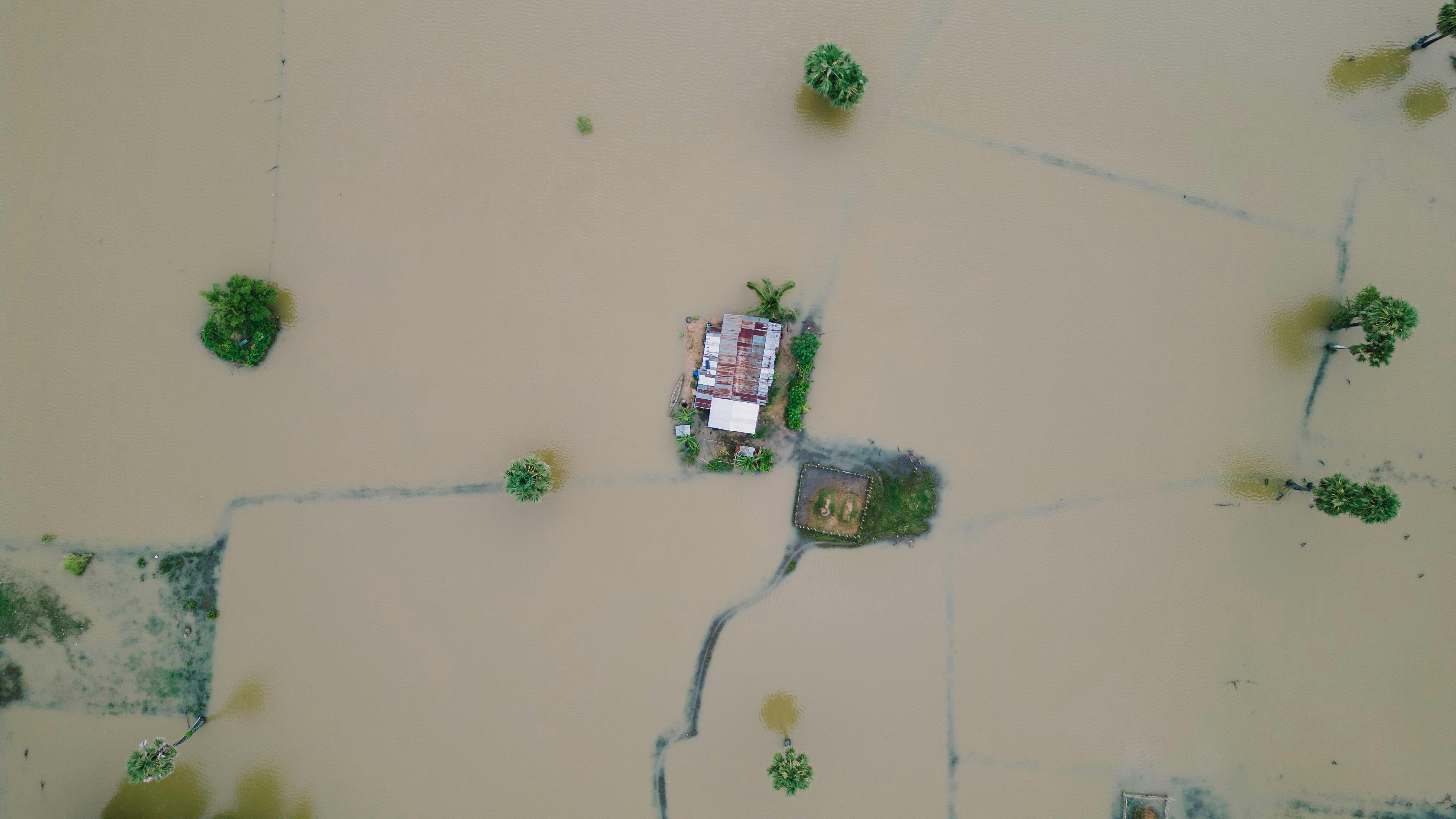
On August 16, 2018, Mariama and her grandchildren woke up to the sight of water seeping through the cracks of their doors; an unexpected flood. It took some time for them to realise that it was not a dream. Within hours, rising waters isolated their house in Kuttanad, and rescue initiatives took two days to reach their premises. Mariama was reluctant to leave her home. “We had no warning. The last time it rained this hard, the river stayed within its banks. Why was this different?” she asked the young volunteer helping her onto the rescue raft. Her experience was not unique. Over a million people were displaced during those days, and the disaster caused deep scars, both on infrastructure and trust in the system, specifically in early warning systems, planning, and safety nets.
We are in an era where alerts, especially red and orange warnings, are becoming increasingly frequent, particularly in Kerala. Known as "God’s Own Country" for its lush greenery and serene backwaters, Kerala now finds itself on the front lines of climate change. The devastating floods of 2018, which displaced over a million people, submerged entire communities, and stretched emergency services to their limits, remain fresh in our memories. Over the past decade, Kerala has faced multiple climate shocks. The 2018 floods, driven by 164% more rainfall in August alone, affected 5.4 million people and caused damages worth ₹27,000 crore (Dhasmana et al., 2023). Landslides, especially in Wayanad and Idukki, have become a recurring disaster, with Kerala reporting the highest incidence nationwide from 2015 to 2022. The Chooralmala landslide on July 30, 2024, was the deadliest in recent Kerala history, resulting in at least 373 deaths, over 200 injuries, and 218 people reported missing. It stands as the most devastating disaster in Kerala’s history in terms of both casualties and impacts damage (Wang et al., 2025). This tragedy highlights the urgent necessity for better disaster preparedness. Since the 2018 floods, a key question persists: Can technology ensure that no family in Kerala is caught unprepared again?
How Artificial Intelligence is Transforming Climate Resilience in Kerala
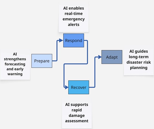
AI is no longer a futuristic concept; it is a critical tool for tackling today’s climate threats. In flood-prone states like Kerala, AI offers more than automation; it acts as an intelligent decision-support system. By thoroughly examining satellite images, weather trends, terrain, and past flood records, AI can accurately pinpoint high-risk areas and initiate early warnings. It can significantly enhance preparedness and save the lives of many. Real-time analytics monitors rainfall, river levels, and soil saturation, providing instant alerts and quicker response to the disaster. Beyond prediction, AI helps authorities pinpoint vulnerable areas, prioritize evacuations, and streamline resource allocation. AI strengthens every phase of disaster management from forecasting and early warning (Prepare), to emergency alerts (Respond), damage assessment (Recover), and long-term planning (Adapt).
1. Predicting the Unpredictable: Preparation and Forecasting
Imagine being able to predict a flood days before it happens. AI-powered predictive modeling makes this possible. AI can forecast flood events accurately by analyzing extensive data, including historical rainfall, river behavior, soil moisture, and reservoir levels. This marks a significant step up from just reacting to emergencies. It focuses more on integrating satellite data from NASA and ISRO to deliver highly localized weather information forecasts. AI models can run complex flood simulations on a laptop in seconds, a task that used to take hours on supercomputers. This foresight helps us allocate resources wisely, plan targeted evacuations, and make preemptive infrastructure changes, saving lives and minimizing damage. Consider "Digital Twins” (virtual models of real environments that integrate real-time and historical data to simulate how those environments might respond under different conditions), of flood-prone areas such as Kochi or Thrissur. Digital AI models can simulate diverse flood scenarios, enabling urban planners to test different response strategies and infrastructure upgrades before the disaster strikes. This approach shifts flood management from a reactive crisis mode to a proactive, preventative strategy.
2. Real-Time Action: Response and Early Warning
When floods are approaching, AI enables us to move from merely predicting to acting immediately. AI-powered IoT sensors placed in rivers and reservoirs continuously track water levels and send immediate alerts when thresholds are exceeded. These sensors collect essential data such as water levels, rainfall, temperature, and humidity, transmitting it for quick analysis. At the same time, AI can analyze social media citizen reports to generate real-time flood maps, providing hyperlocal insights during emergencies. Tools like MIT’s Urban Risk Lab’s RiskMap (a free, crowd-sourced, and transparent platform to harness civic sensing for collective disaster management) are already being used worldwide. For example, a professor from IIT Madras, Balaji Narasimhan, used MIT's Urban Risk Map to gather flood data and create flood maps for Chennai during the city’s floods. These examples demonstrate how combining predictive simulation with real-time community data can create a flood resilience system that is more responsive, adaptable, and inclusive (MIT, 2021).
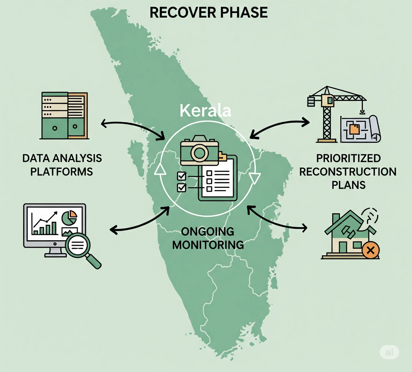
3. Healing and Rebuilding: Post-Disaster Recovery
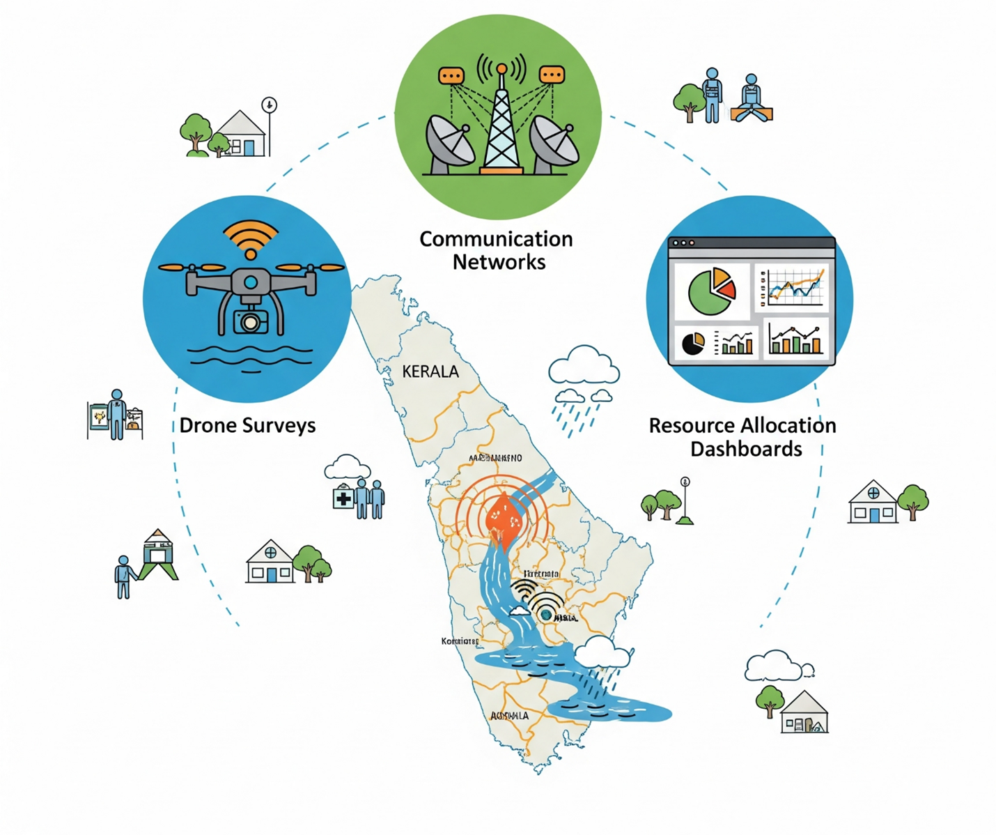
Flood aftermaths are chaotic, but AI offers clarity. Drones powered by AI can perform aerial surveys to evaluate damage swiftly, locate inaccessible areas, and support rescue efforts. This method is much faster and safer than manual inspections. Object detection algorithms (a class of computer vision techniques designed to identify and locate instances of objects within images or videos) can analyze thousands of drone images in real-time, automatically identifying and measuring damage to structures and infrastructure. Real-time data-driven dashboards provide disaster teams with a comprehensive visual overview of the flood scope, relief camp availability, and supply chains. AI-based analytics improve the coordination of relief activities, speeding up recovery and reconstruction. Additionally, AI can generate realistic simulation scenarios for training volunteers and responders, boosting their preparedness for future disasters.
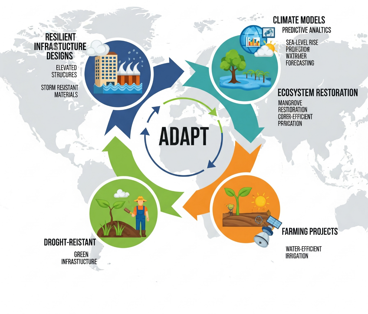
4. Building a Stronger Future: Long-Term Adaptation
AI's function includes developing long-term adaptation strategies. In urban planning, machine learning (ML) algorithms can aid in redesigning cities to better withstand flooding. ML can optimize city layouts, drainage systems, and infrastructure placement to reduce flood damage and enhance response times during flooding events. This involves optimizing land use, enhancing drainage systems, and incorporating green infrastructure. AI can determine the best locations for flood-resistant buildings and embankments by analyzing complex factors like soil type and rainfall patterns. The potential economic benefits of AI are also significantly greater. A Deloitte Global report estimates that AI could save about US$70 billion annually in direct natural disaster costs worldwide by 2050 (Deloitte, 2025). For displaced individuals, AI-driven mobile banking and digital identity systems offer easy access to financial aid, aiding them in faster recovery. This proactive application of AI in development planning helps create a New Kerala that is better equipped to withstand future climate shocks, promoting sustainable growth and preserving ecological health.
Recent Stories of AI adoption in Kerala’s Disaster Preparedness
Kerala has been proactively adopting innovative technologies to improve flood prediction, preparedness, and community resilience. Here are some recent practical examples.
IDRIS, India’s first integrated disaster management system, is turning Idukki district into a resilience model by leveraging real-time data, AI, satellite imagery, and sensor networks. It helps to monitor and forecast hazards like landslides, flash floods, wildfires, and droughts. Led by the District Disaster Management Authority, it employs 46 soil and moisture sensors along with 48 river gauges to provide real-time data to a GIS-based control center, improving early warning systems and infrastructure planning. Multilingual alerts are disseminated through SMS, sirens, radio, and a mobile app to help Idukki become the most disaster-resilient hill district in the country (Press Trust of India, 2025).
CoS-IT-FloWS (Community Sourced Impact-Based Flood Forecast and Early Warning System) is an open-source project created by EQUINOCT Community Sourced Modelling Solutions, with support from the UNICEF Office of Innovation's Venture Capital Fund (EQUINOCT, 2023). As a member of UNICEF’s first climate cohort, EQUINOCT is among eight global startups developing sustainable, open-source climate solutions. Similarly, in Puthenvelikkara, a grassroots flood monitoring project involves retired teachers and students frequently measuring water and rainfall levels. The data is shared through WhatsApp with local groups such as the Community Resource Centre (CRC) and Meenachil River Protection Council (MRPC). This community-sourced data powers an AI-based app that forecasts water level increases, allowing for prompt evacuation and response. Inspired by the devastating floods of 2018, this initiative demonstrates how local involvement and technology can work together to enhance flood resilience and disaster response, especially through hyper-local advanced weather prediction (Shaji, 2024).
A collaborative study in 2025 on landslides in Wayanad identified persistent gaps in technological coordination and early warning systems. The report recommends installing IoT sensors, Doppler radars, high-resolution mapping, and AI-based predictive models. It emphasizes shifting from technology-centric alerts to community-based resilience strategies, known as the 'first mile' approach. The report titled ‘Wayanad Landslides 2024: Early Warning System - Changing the Last Mile to the First Mile’ was published in Kozhikode on August 6, 2025. (The Hindu 2025). A high-resolution flood inundation map for Thrikkakara Municipality, Kerala, has been developed using detailed Digital Elevation Model (DEM) data to assist disaster preparedness and urban planning. The map highlights flood-prone areas, enabling authorities to plan evacuations, promote sustainable growth, and inform residents about safety measures. This effort aims to strengthen the community's resilience against monsoon floods. Moreover, Kerala’s capital city is testing a digital twin system to map urban assets such as buildings and monitor property tax compliance. Although not designed for floods, this drone-powered virtual mapping could eventually be adapted for real-time urban flood simulations.
Way forward and challenges: Ethical and Inclusive AI
To effectively enhance Kerala’s Community Resilience Framework (CRIF) through AI, governance should focus on ethics, inclusion, and empowering local communities. Key priorities involve forming Community-AI Governance Councils composed of diverse stakeholders to supervise AI tools throughout their lifecycle, inspired by models like Barcelona’s City Data Commons (Mohamed, 2020). Similarly, algorithmic transparency is also crucial, requiring disaster-prediction systems to disclose their data sources, logic, and assumptions, following the framework of Canada’s Algorithmic Impact Assessment (Government of Canada, 2025). Involving flood-affected and marginalized communities in participatory design ensures that AI solutions are rooted in their real-life experiences. Simultaneously, privacy-focused data infrastructure, such as Estonia’s X-Road, leverages anonymization and secure data exchanges to safeguard sensitive information (X-Road, 2024). Achieving long-term sustainability involves enhancing local AI capabilities by creating Kerala-specific models through universities, startups, and citizen science initiatives. This promotes “AI Localism,” which refers to designing, developing, and governing artificial intelligence systems at the local or community level instead of relying solely on centralized, top-down, or global models.
However, several challenges still exist unaddressed. Despite advances, significant challenges remain, such as data scarcity, high implementation costs, the absence of hybrid models for post-disaster management, and limited application of explainable AI techniques. We need more comprehensive and integrated frameworks that bring together AI, image processing, social media analytics, and community engagement throughout all stages of disaster management. Moreover, addressing data quality and interoperability gaps is essential for effective AI modeling. The digital divide risks excluding vulnerable communities unless efforts to improve digital literacy and access are increased. Maintaining AI initiatives demands substantial funding, infrastructure, and skilled personnel. To reduce the environmental footprint, it is essential to adopt ‘green AI’ innovations focused on energy efficiency and sustainability and to utilize renewable energy sources. Finally, addressing ethical and governance risks, such as privacy breaches, bias, and misinformation, requires implementing strong frameworks to protect trust and fairness.
Laying the foundation for a resilient Kerala
Kerala’s move towards AI-based climate resilience signifies more than just technology; it reflects a broader societal change. With robust digital literacy, advanced governance, and established frameworks such as CRIF and IDRIS, the state is well-positioned to become a global benchmark in disaster preparedness. The next advancement requires explainable and hybrid AI models that foster trust through transparency. It also calls for community engagement to promote inclusivity and innovative approaches to address data challenges and costs barriers. By combining human insight, ethical governance, and advanced analytics, Kerala can shift from reactive disaster relief to proactive, adaptable resilience to Climate change events. This is not just about mitigating floods; it's about empowering communities, building trust between citizens and the government, and creating a future where climate shocks are addressed with readiness rather than reaction panic.
Further developments should focus on creating AI models that are both transparent and interpretable, combining multiple approaches to enhance trust and effectiveness in real-world disaster response scenarios in Kerala. Strategies to actively involve local communities and marginalized groups are essential to ensure that AI solutions are context-sensitive, socially inclusive, and sustainable over the long term. Research should explore innovative methods to overcome limited data availability and high costs, enabling broader and equitable adoption of AI technologies for flood resilience across Kerala.
By adopting this integrated approach, Kerala has the potential to become a leading example of sustainable, people-centered climate action worldwide. Through effective governance, ethical AI practices, and continuous community engagement, Kerala can serve as a global model for SDG 13. It shows that when public trust aligns with AI capabilities, climate challenges can be turned into opportunities for resilient and inclusive solutions.
References
Al Abdouli, K. M., Rai, A., Tenzin, G., Gayleg, U., Chhetri, N., & Chhetri, A. (2024). Real-time flood forecasting in Amo Chhu using machine learning model and internet of things. Cogent Engineering, 11(1), 2370900. https://doi.org/10.1080/23311916.2024.2370900
Ali, S., George, A. Modelling a community resilience index for urban flood-prone areas of Kerala, India (CRIF). Nat Hazards 113, 261–286 (2022). https://doi.org/10.1007/s11069-022-05299-7
Andrae, S., & Tariq, M. U. (2025). Artificial intelligence in disaster management: Sustainable response and recovery. In Cases on AI-driven solutions to environmental challenges (Chapter 4). IGI Global.
Atlantis Press. (2024). Urban flood mitigation: A comparative study of Zhengzhou (China) and Mumbai (India) and the role of AI. Atlantis Press.
Aurassure. (2025). Flood monitoring. Retrieved August 12, 2025, from https://aurassure.com/flood-monitoring/
Berkman Klein Center. (2021). AI: Global governance and inclusion. Retrieved August 12, 2025, from https://cyber.harvard.edu/projects/ai-global-governance-and-inclusion
Camacho, C., Webb, R., Bower, P., & Munford, L. (2024). Adapting the Baseline Resilience Indicators for Communities (BRIC) Framework for England: Development of a Community Resilience Index. International Journal of Environmental Research and Public Health, 21. https://doi.org/10.3390/ijerph21081012
CDIT. (2024). Centre for Development of Imaging Technology.
Chang, L.-C., Yang, M.-T., Liou, J.-Y., Kow, P.-Y., & Chang, F.-J. (2025). Intelligent Urban Flood Management Using Real-Time Forecasting, Multi-Objective Optimization, and Adaptive Pump Operation. Smart Cities, 8(3), 91. https://doi.org/10.3390/smartcities8030091
Deloitte. (2025). AI for infrastructure resilience. Deloitte.https://www.deloitte.com/content/dam/assets-shared/docs/about/2025/ai-for-infrastructure-resilience.pdf
Dhasmana, M., Mondal, A., & Zachariah, M. (2023). On the role of climate change in the 2018 flooding event in Kerala. Environmental Research Letters, 18. https://doi.org/10.1088/1748-9326/ace6c0
Economic Times. (2024). From the 2019 floods to the 2024 Wayanad landslides: Why are deadly disasters repeatedly hitting Kerala? The Economic Times.
EQUINOCT. (2023). CoS-IT-FloWS Documentation. Read the Docs. Retrieved August 12, 2025, from https://cos-it-flows-documentation.readthedocs.io/en/latest/
FIU News. (2025). How AI might become the future of hurricane flood forecasting. Florida International University News.
Government of Canada. (2025, July 20). Algorithmic impact assessment tool. In Responsible use of artificial intelligence in government. Canada.ca. Retrieved August 12, 2025, from https://www.canada.ca/en/government/system/digital-government/digital-government-innovations/responsible-use-ai/algorithmic-impact-assessment.html
Lu, Y., & Gong, P. (2024). Integrating GIS Community Resilience Assessment: Multidisaster Perspective. ASCE-ASME Journal of Risk and Uncertainty in Engineering Systems, Part A: Civil Engineering. https://doi.org/10.1061/ajrua6.rueng-1220
Mohamed, S. (2020, September 10). Cities & data sharing — Part 3: Barcelona. The Data Economy Lab. https://thedataeconomylab.com/2020/09/10/cities-data-sharing-part-3-barcelona/
NCDP. (2025). Transforming disaster management: The promise and challenges of AI in wildfire damage assessment. Retrieved August 12, 2025, from [Insert URL]
NDTV. (2025). Kerala's Idukki turns to AI, sensors to become most disaster-ready hill district. NDTV.
Penn State University. (2025). Improving predictions of flood severity, place, and time with AI.
Potts, J., Torrance, A., Harhoff, D., & von Hippel, E. (2023). Profiting from data commons: Theory, evidence, and strategy implications. Strategy Science, 9(1), 1–14. https://doi.org/10.1287/stsc.2021.0080
PreventionWeb. (2019). The great Kerala floods 2018. PreventionWeb.
Raj, R., & Sofi, A. (2023). Does climate change leads to severe household-level vulnerability? Evidence from the Western Ghats of Kerala, India. Land Use Policy. https://doi.org/10.1016/j.landusepol.2023.106655
Rigaud, K., de Sherbinin, A., Jones, B., et al. (2018). Groundswell: Preparing for internal climate migration. World Bank.
Shaji, K. A. (2024, December 6). Hyper-local climate predictions to protect Kerala from extreme weather events. Mongabay India. https://india.mongabay.com/2024/12/hyper-local-climate-predictions-to-protect-kerala-from-extreme-weather-event/
State Planning Board, Kerala. (n.d.). Disaster management – 14th five-year plan working group report.
Tariq, H., Pathirage, C., & Fernando, T. (2021). Measuring community disaster resilience at local levels: An adaptable resilience framework. International Journal of Disaster Risk Reduction. https://doi.org/10.1016/J.IJDRR.2021.102358
UNDP. (2025). UNDP Asia and Pacific launches Una, world's first AI environment champion.
UNESCO. (2025). UNOC3: Grassroots ocean projects prove power of citizen action.https://www.unesco.org/en/articles/unoc3-grassroots-ocean-projects-prove-power-citizen-action
UNFCCC. (2025). AI for climate action.https://unfccc.int/news/ai-and-climate-action-opportunities-risks-and-challenges-for-developing-countries
Urban Risk Lab, MIT (2021). [https://urbanrisklab.mit.edu/]
Wang, Q., Xu, C., Ma, J., Huang, Y., Zhang, S., & Gao, H. (2025). Preliminary analysis of the July 30, 2024, Wayanad landslide disaster in India: Causes and impacts. Natural Hazards Research. Advance online publication. https://doi.org/10.1016/j.nhres.2025.04.005
World Bank. (2021). India - Resilient Kerala Program Program-for-Results Project (English). Washington, D.C. : World Bank Group. http://documents.worldbank.org/curated/en/336631624845811459
World Economic Forum. (2022). How AI can help climate migration.https://www.weforum.org/stories/2022/11/how-ai-can-help-climate-migration/
X-Road. (2024). Technology overview. In X-Road®. Retrieved August 12, 2025, from https://x-road.global/x-road-technology-overview

Copyright © 2026. Rajagiri Business School. All Rights Reserved. Website Designed and Maintained by Intersmart